- Aujourd'hui
- Dimanche
- Lundi
- Mardi
- Mercredi
- Jeudi
- Vendredi
Thespot2be model
Date
Confiance/3
Météo
Vent (knt)
Rafale (knt)
Vagues (m)
Période (sec)
Direction (vagues)
Sa 31 12h
3/3
5
12
6.3
0
Sa 31 13h
2/3
6
11
6.1
0
Sa 31 14h
2/3
7
14
5.8
0
Sa 31 15h
2/3
6
14
5.6
0
Sa 31 16h
3/3
5
11
5.4
0
Sa 31 17h
3/3
6
14
5.2
0
Sa 31 18h
3/3
5
11
5.0
0
Sa 31 19h
3/3
5
7
4.8
0
Sa 31 20h
3/3
6
9
4.8
0
Sa 31 21h
3/3
6
9
4.8
0
Sa 31 22h
3/3
5
8
4.8
0
Di 01 06h
3/3
6
10
4.3
0
Di 01 07h
3/3
6
11
4.2
0
Di 01 08h
3/3
6
12
4.1
0
Di 01 09h
2/3
7
13
4.0
0
Di 01 10h
3/3
7
14
3.9
0
Di 01 11h
2/3
8
15
3.9
0
Di 01 12h
3/3
8
18
3.8
0
Di 01 13h
2/3
9
17
3.8
0
Di 01 14h
2/3
10
18
3.9
0
Di 01 15h
3/3
9
18
3.9
0
Di 01 16h
3/3
8
15
3.9
0
Di 01 17h
3/3
7
15
4.0
0
Di 01 18h
2/3
6
13
4.0
0
Di 01 19h
2/3
5
13
4.1
0
Di 01 20h
2/3
5
12
4.2
0
Di 01 21h
1/3
5
11
4.3
0
Di 01 22h
2/3
6
13
4.5
0
Lu 02 06h
2/3
9
19
5.2
0
Lu 02 07h
2/3
9
22
5.2
0
Lu 02 08h
2/3
10
21
5.1
0
Lu 02 09h
2/3
10
21
4.9
0
Lu 02 10h
3/3
11
25
4.6
0
Lu 02 11h
3/3
11
24
4.4
0
Lu 02 12h
3/3
12
25
4.4
0
Lu 02 13h
3/3
12
24
4.3
0
Lu 02 14h
3/3
12
25
4.3
0
Lu 02 15h
3/3
12
24
4.4
0
Lu 02 16h
2/3
11
23
4.4
0
Lu 02 17h
3/3
12
24
4.3
0
Lu 02 18h
3/3
13
25
4.2
0
Lu 02 19h
2/3
11
25
4.2
0
Lu 02 20h
2/3
12
25
0
0
Lu 02 21h
2/3
12
25
0
0
Lu 02 22h
2/3
10
24
0
0
Ma 03 06h
3/3
10
19
0
0
Ma 03 07h
3/3
10
18
0
0
Ma 03 08h
3/3
10
19
0
0
Ma 03 09h
3/3
9
17
0
0
Ma 03 10h
3/3
9
18
0
0
Ma 03 11h
3/3
9
17
0
0
Ma 03 12h
2/3
10
18
0
0
Ma 03 13h
2/3
10
19
0
0
Ma 03 14h
3/3
11
21
0
0
Ma 03 15h
3/3
11
21
0
0
Ma 03 16h
2/3
13
22
0
0
Ma 03 17h
3/3
9
18
0
0
Ma 03 18h
2/3
7
16
0
0
Ma 03 19h
2/3
7
16
0
0
Ma 03 20h
2/3
6
15
0
0
Ma 03 21h
2/3
6
15
0
0
Ma 03 22h
2/3
7
17
0
0
Me 04 06h
2/3
8
17
0
0
Me 04 07h
2/3
8
19
0
0
Me 04 08h
2/3
8
17
0
0
Me 04 09h
2/3
7
17
0
0
Me 04 10h
2/3
7
17
0
0
Me 04 11h
2/3
8
17
0
0
Me 04 12h
2/3
9
18
0
0
Me 04 13h
2/3
10
18
0
0
Me 04 14h
2/3
10
18
0
0
Me 04 15h
1/3
9
17
0
0
Me 04 16h
1/3
9
17
0
0
Me 04 17h
1/3
9
16
0
0
Me 04 18h
1/3
8
15
0
0
Me 04 19h
1/3
9
15
0
0
Me 04 20h
1/3
9
15
0
0
Me 04 21h
1/3
9
16
0
0
Me 04 22h
1/3
9
17
0
0
Je 05 06h
2/3
8
14
0
0
Je 05 07h
2/3
8
15
0
0
Je 05 08h
2/3
8
16
0
0
Je 05 09h
2/3
9
17
0
0
Je 05 10h
2/3
9
19
0
0
Je 05 11h
3/3
10
21
0
0
Je 05 12h
3/3
10
23
0
0
Je 05 13h
3/3
11
25
0
0
Je 05 14h
3/3
11
24
0
0
Je 05 15h
2/3
10
22
0
0
Je 05 16h
2/3
10
20
0
0
Je 05 17h
2/3
10
20
0
0
Je 05 18h
2/3
10
21
0
0
Je 05 19h
2/3
11
21
0
0
Je 05 20h
2/3
10
20
0
0
Je 05 21h
2/3
9
18
0
0
Je 05 22h
2/3
8
17
0
0
OPEN METEO
Prévision à 16 jours utilisant le modèle le plus fin disponibleDate
Vent (knt)
Rafale (knt)
Direction (vent)
Précipitations (mm)
Sa 31 12h
6
10
0
Sa 31 13h
8
14
0
Sa 31 14h
9
16
0
Sa 31 15h
7
15
0
Sa 31 16h
7
15
0
Sa 31 17h
7
14
0
Sa 31 18h
5
11
0
Sa 31 19h
6
9
0
Sa 31 20h
6
10
0
Sa 31 21h
6
10
0
Sa 31 22h
6
10
0
Sa 31 23h
6
10
0
Di 01 04h
5
8
0
Di 01 05h
6
9
0
Di 01 06h
6
9
0
Di 01 07h
7
11
1
Di 01 08h
6
12
2
Di 01 09h
9
14
3
Di 01 10h
8
15
2
Di 01 11h
9
15
0
Di 01 12h
10
17
0
Di 01 13h
12
20
0
Di 01 14h
12
21
0
Di 01 15h
10
20
0
Di 01 16h
9
17
0
Di 01 17h
6
13
0
Di 01 18h
4
8
0
Di 01 19h
3
5
0
Di 01 20h
2
5
0
Di 01 21h
1
3
0
Di 01 22h
2
3
0
Di 01 23h
1
4
0
Lu 02 04h
4
7
0
Lu 02 05h
5
9
0
Lu 02 06h
6
10
0
Lu 02 07h
7
13
0
Lu 02 08h
7
14
0
Lu 02 09h
8
14
0
Lu 02 10h
10
18
0
Lu 02 11h
10
18
0
Lu 02 12h
11
19
0
Lu 02 13h
11
19
0
Lu 02 14h
11
19
0
Lu 02 15h
11
19
0
Lu 02 16h
10
18
2
Lu 02 17h
11
19
1
Lu 02 18h
12
20
1
Lu 02 19h
12
20
1
Lu 02 20h
11
20
0
Lu 02 21h
10
19
1
Lu 02 22h
8
17
1
Lu 02 23h
5
14
0
Ma 03 04h
7
13
0
Ma 03 05h
6
12
0
Ma 03 06h
11
19
0
Ma 03 07h
11
20
0
Ma 03 08h
10
18
0
Ma 03 09h
8
15
0
Ma 03 10h
8
13
0
Ma 03 11h
8
15
0
Ma 03 12h
8
18
0
Ma 03 13h
9
21
0
Ma 03 14h
10
22
0
Ma 03 15h
10
22
0
Ma 03 16h
10
21
0
Ma 03 17h
8
17
0
Ma 03 18h
5
12
0
Ma 03 19h
4
8
0
Ma 03 20h
4
7
0
Ma 03 21h
4
6
0
Ma 03 22h
4
6
0
Ma 03 23h
4
7
0
Me 04 04h
5
9
0
Me 04 05h
5
9
0
Me 04 06h
5
9
0
Me 04 07h
5
9
0
Me 04 08h
5
9
0
Me 04 09h
5
9
0
Me 04 10h
5
9
0
Me 04 11h
5
10
0
Me 04 12h
6
12
0
Me 04 13h
7
13
0
Me 04 14h
7
13
0
Me 04 15h
6
13
0
Me 04 16h
5
12
0
Me 04 17h
4
9
0
Me 04 18h
2
6
0
Me 04 19h
2
4
0
Me 04 20h
2
4
0
Me 04 21h
3
4
0
Me 04 22h
3
5
0
Me 04 23h
3
5
0
Je 05 04h
4
7
0
Je 05 05h
4
8
0
Je 05 06h
5
9
0
Je 05 07h
6
10
0
Je 05 08h
6
12
0
Je 05 09h
7
13
0
Je 05 10h
8
15
0
Je 05 11h
9
17
0
Je 05 12h
10
21
0
Je 05 13h
10
22
0
Je 05 14h
10
21
0
Je 05 15h
9
18
0
Je 05 16h
8
15
0
Je 05 17h
7
14
1
Je 05 18h
7
14
1
Je 05 19h
7
14
1
Je 05 20h
7
13
0
Je 05 21h
7
13
0
Je 05 22h
7
13
0
Je 05 23h
6
12
0
Ve 06 04h
2
6
0
Ve 06 05h
2
6
0
Ve 06 06h
3
7
0
Ve 06 07h
4
8
0
Ve 06 08h
5
9
0
Ve 06 09h
6
11
0
Ve 06 10h
7
13
0
Ve 06 11h
7
14
0
Ve 06 12h
8
15
0
Ve 06 13h
8
16
0
Ve 06 14h
10
18
0
Ve 06 15h
11
21
0
Ve 06 16h
12
23
0
Ve 06 17h
12
23
0
Ve 06 18h
11
22
0
Ve 06 19h
10
20
0
Ve 06 20h
9
19
0
Ve 06 21h
8
17
0
Ve 06 22h
8
16
0
Ve 06 23h
8
15
0
Sa 07 04h
6
13
0
Sa 07 05h
6
12
0
Sa 07 06h
6
12
0
Sa 07 07h
6
12
0
Sa 07 08h
6
11
0
Sa 07 09h
5
10
0
Sa 07 10h
6
10
0
Sa 07 11h
8
14
0
Sa 07 12h
10
18
0
Sa 07 13h
12
20
0
Sa 07 14h
13
20
0
Sa 07 15h
13
19
0
Sa 07 16h
12
18
0
Sa 07 17h
10
17
0
Sa 07 18h
8
16
0
Sa 07 19h
7
15
0
Sa 07 20h
6
14
0
Sa 07 21h
6
12
0
Sa 07 22h
6
11
0
Sa 07 23h
6
12
0
Di 08 04h
4
3
0
Di 08 05h
4
3
0
Di 08 06h
3
5
0
Di 08 07h
4
8
0
Di 08 08h
5
11
0
Di 08 09h
7
14
0
Di 08 10h
8
16
0
Di 08 11h
8
14
0
Di 08 12h
7
10
0
Di 08 13h
6
7
0
Di 08 14h
6
7
0
Di 08 15h
6
8
0
Di 08 16h
6
9
0
Di 08 17h
6
9
0
Di 08 18h
6
8
0
Di 08 19h
7
9
0
Di 08 20h
7
12
0
Di 08 21h
8
17
0
Di 08 22h
9
20
0
Di 08 23h
9
21
0
Lu 09 04h
14
27
0
Lu 09 05h
16
30
0
Lu 09 06h
18
32
0
Lu 09 07h
19
33
0
Lu 09 08h
16
30
0
Lu 09 09h
12
26
0
Lu 09 10h
10
22
0
Lu 09 11h
12
24
0
Lu 09 12h
15
26
0
Lu 09 13h
17
29
0
Lu 09 14h
19
32
0
Lu 09 15h
20
34
0
Lu 09 16h
21
36
0
Lu 09 17h
21
37
0
Lu 09 18h
20
37
0
Lu 09 19h
20
38
0
Lu 09 20h
21
40
0
Lu 09 21h
23
42
0
Lu 09 22h
25
44
0
Lu 09 23h
27
48
0
Ma 10 04h
30
49
0
Ma 10 05h
28
45
0
Ma 10 06h
26
41
0
Ma 10 07h
23
37
0
Ma 10 08h
19
32
0
Ma 10 09h
15
26
0
Ma 10 10h
12
23
0
Ma 10 11h
13
25
0
Ma 10 12h
15
29
0
Ma 10 13h
17
33
0
Ma 10 14h
19
36
0
Ma 10 15h
20
38
0
Ma 10 16h
21
40
0
Ma 10 17h
21
39
0
Ma 10 18h
20
37
0
Ma 10 19h
19
35
0
Ma 10 20h
18
32
0
Ma 10 21h
17
29
0
Ma 10 22h
16
27
0
Ma 10 23h
15
27
0
Me 11 04h
22
39
0
Me 11 05h
22
39
0
Me 11 06h
21
37
0
Me 11 07h
21
36
0
Me 11 08h
21
35
0
Me 11 09h
21
35
0
Me 11 10h
22
35
0
Me 11 11h
22
36
0
Me 11 12h
22
38
0
Me 11 13h
23
40
0
Me 11 14h
23
41
0
Me 11 15h
23
41
0
Me 11 16h
24
42
0
Me 11 17h
24
42
0
Me 11 18h
25
41
0
Me 11 19h
25
41
0
Me 11 20h
24
40
0
Me 11 21h
23
40
0
Me 11 22h
22
39
0
Me 11 23h
20
36
0
Je 12 04h
13
22
0
Je 12 05h
12
21
0
Je 12 06h
11
20
0
Je 12 07h
10
20
0
Je 12 08h
10
20
0
Je 12 09h
10
20
0
Je 12 10h
11
19
0
Je 12 11h
11
19
0
Je 12 12h
12
18
0
Je 12 13h
12
19
0
Je 12 14h
12
21
0
Je 12 15h
12
24
0
Je 12 16h
13
27
0
Je 12 17h
14
30
0
Je 12 18h
14
32
0
Je 12 19h
16
33
0
Je 12 20h
17
34
0
Je 12 21h
18
35
0
Je 12 22h
19
35
0
Je 12 23h
19
34
0
Ve 13 04h
19
34
0
Ve 13 05h
20
35
0
Ve 13 06h
20
36
0
Ve 13 07h
21
36
0
Ve 13 08h
20
35
0
Ve 13 09h
20
34
0
Ve 13 10h
20
33
0
Ve 13 11h
20
33
0
Ve 13 12h
22
35
0
Ve 13 13h
22
36
0
Ve 13 14h
22
36
0
Ve 13 15h
21
35
0
Ve 13 16h
19
34
0
Ve 13 17h
18
32
0
Ve 13 18h
17
29
0
Ve 13 19h
16
27
0
Ve 13 20h
15
27
0
Ve 13 21h
14
26
0
Ve 13 22h
14
26
0
Ve 13 23h
12
26
0
Sa 14 04h
10
19
0
Sa 14 05h
9
18
0
Sa 14 06h
9
18
0
Sa 14 07h
9
18
0
Sa 14 08h
9
17
0
Sa 14 09h
9
17
0
Sa 14 10h
9
16
0
Sa 14 11h
9
17
0
Sa 14 12h
10
18
0
Sa 14 13h
10
18
0
Sa 14 14h
9
16
0
Sa 14 15h
9
14
0
Sa 14 16h
9
12
0
Sa 14 17h
8
13
0
Sa 14 18h
8
14
0
Sa 14 19h
9
16
0
Sa 14 20h
10
20
0
Sa 14 21h
11
24
0
Sa 14 22h
11
27
0
Sa 14 23h
12
29
0
Di 15 04h
14
32
0
Di 15 05h
14
30
0
Di 15 06h
13
26
0
Di 15 07h
14
22
0
Di 15 08h
13
21
0
Di 15 09h
11
21
0
Di 15 10h
10
20
0
Di 15 11h
11
20
0
Di 15 12h
12
20
0
Di 15 13h
13
20
0
Di 15 14h
13
19
0
Di 15 15h
12
19
0
Di 15 16h
12
18
0
Di 15 17h
10
18
0
Di 15 18h
9
18
0
Di 15 19h
8
18
0
Di 15 20h
8
18
0
Di 15 21h
7
17
0
Di 15 22h
7
17
0
Di 15 23h
7
16
0
WRF 12km
Date
Vent (knt)
Rafale (knt)
Direction (vent)
Sa 31 13h
4
5
Sa 31 16h
4
4
Sa 31 19h
3
3
Sa 31 22h
5
5
Di 01 04h
4
4
Di 01 07h
4
9
Di 01 10h
6
11
Di 01 13h
7
13
Di 01 16h
7
12
Di 01 19h
5
15
Di 01 22h
6
16
Lu 02 04h
6
24
Lu 02 07h
8
26
Lu 02 10h
10
29
Lu 02 13h
10
22
Lu 02 16h
10
21
Lu 02 19h
9
26
Lu 02 22h
7
22
Ma 03 04h
6
16
Ma 03 07h
8
14
Ma 03 10h
10
22
Ma 03 13h
9
15
Ma 03 16h
18
25
Ma 03 19h
8
20
Ma 03 22h
7
20
Me 04 04h
7
28
Me 04 07h
8
21
dwd
Date
Vent (knt)
Direction (vent)
Sa 31 12h
4
Sa 31 13h
4
Sa 31 14h
4
Sa 31 15h
4
Sa 31 16h
4
Sa 31 17h
2
Sa 31 18h
3
Sa 31 19h
3
Sa 31 20h
3
Sa 31 21h
2
Di 01 06h
3
Di 01 07h
3
Di 01 08h
3
Di 01 09h
4
Di 01 10h
5
Di 01 11h
4
Di 01 12h
5
Di 01 13h
4
Di 01 14h
4
Di 01 15h
3
Di 01 16h
1
Di 01 17h
1
Di 01 18h
1
Di 01 19h
1
Di 01 20h
0
Di 01 21h
1
Lu 02 06h
2
Lu 02 07h
3
Lu 02 08h
3
Lu 02 09h
4
Lu 02 10h
4
Lu 02 11h
5
Lu 02 12h
5
Lu 02 13h
5
Lu 02 14h
5
Lu 02 15h
5
Lu 02 16h
6
Lu 02 17h
6
Lu 02 18h
6
Lu 02 19h
6
Lu 02 20h
6
Lu 02 21h
5
Ma 03 06h
3
Ma 03 07h
3
Ma 03 08h
3
Ma 03 09h
3
Ma 03 10h
3
Ma 03 11h
4
Ma 03 12h
5
Ma 03 13h
6
Ma 03 14h
5
Ma 03 15h
5
Ma 03 16h
5
Ma 03 17h
4
Ma 03 18h
4
Ma 03 19h
3
Ma 03 20h
3
Ma 03 21h
3
Me 04 06h
3
Me 04 07h
3
Me 04 08h
3
Me 04 09h
3
Me 04 10h
3
Me 04 11h
4
Me 04 12h
4
Me 04 13h
4
Me 04 14h
0
Me 04 15h
0
Me 04 16h
0
Me 04 17h
0
Me 04 18h
0
Me 04 19h
0
Me 04 20h
0
Me 04 21h
0
Je 05 06h
0
Je 05 07h
0
Je 05 08h
0
Je 05 09h
0
Je 05 10h
0
Je 05 11h
0
Je 05 12h
0
Je 05 13h
0
Je 05 14h
0
Je 05 15h
0
Je 05 16h
0
Je 05 17h
0
Je 05 18h
0
Je 05 19h
0
Je 05 20h
0
Je 05 21h
0
Marée du port : LA LOIRE (NANTES , CHANTENAY)
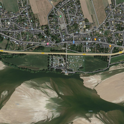
La Daguenière - Windsurf
FR : Spot de Windsurf. Le spot fonctionne par vent de Ouest-Sud-Ouest à Ouest, le top étant l'Ouest. Il y a du clapot quand le vent est assez fort sinon c'est plutôt plat. Les spots sur la Loire sont plutôt pour des niveaux confirmés et experts. Pour les windsurfer il faut à minima maitriser le jibe et le waterstart et pour les kiteurs bien faire attention de ne pas perdre leurs boards dans le courant. Comme partout sur la Loire, les bancs de sables bougent et les hauteurs d'eau varient. Le spot n'est praticable qu'avec un niveau d'eau de la Loire bien supérieur aux autres spots à cause du banc de sable central (+ 0,50 à Saumur). Les dangers sont nombreux : Il faut faire attention à l'orientation du vent, au courant et tourbillons, il faut également faire attention au niveau d'eau et au débit d'eau. Il peut y avoir des branches, tronc d'arbre et surtout des "culs de grève" (ce sont des bancs de sable, semblant très fiables, qui peuvent s'écrouler à tout moment et vous faire passer de 30 centimètres à 3 mètres de profondeur). La mise à l'eau peut varier en fonction de l'évolution des bancs de sable. Sur toute la rive droite de la Loire entre La Daguenière et La Ménitré il y a de nombreuses cales d’accès à l’eau qui permettent la mise à l’eau selon le niveau de la Loire et les bancs de sable. Les coordonnées de mise à l’eau sont donc à titre indicatif. Même en l’absence de signalisation, la réglementation des aires de protection Biotope s’applique pendant la période de reproduction des sternes, soit du 1er avril au 15 août et concerne tous les bancs de sable de la Loire non accessibles à pied sec, de Saumur à Montsoreau et de La Daguenière au Thoureil. "L’accès aux îlots concernés est interdit, tout comme l’accostage, le stationnement des embarcations, la divagation d’animaux domestiques, le bivouac, le camping et les feux". Merci à Dominique et Julien pour ces informations. Plus d'informations sur le Blog de Dominique : https://lacdemaine.blog4ever.com/spots-en-loire Pour connaitre la hauteur de l'eau sur la Loire à Saumur, il faut regarder le lien ci-dessous. ----------------------- EN : Windsurf spot. The spot works with West-South-West to West wind, the top being West. There is some chop when the wind is strong enough, otherwise it is rather flat. The spots on the Loire are more for advanced and expert surfers. For windsurfers you need to master the jibe and the waterstart and for kiteboarders you have to be careful not to lose your boards in the current. As everywhere on the Loire, the sandbanks move and the water level varies. The spot is only practicable with a water level of the Loire much higher than the other spots because of the central sandbank (+ 0,50 in Saumur). The dangers are numerous: You have to be careful with the wind direction, the current and the whirlpools, you also have to be careful with the water level and the water flow. There may be branches, tree trunks and especially "culs de grève" (these are sandbanks, seemingly very reliable, which can collapse at any time and make you go from 30 centimeters to 3 meters deep). The launching time can vary according to the evolution of the sandbanks. On the whole right bank of the Loire between La Daguenière and La Ménitré there are many slips that allow you to launch according to the level of the Loire and the sandbanks. The launching coordinates are therefore indicative. Even in the absence of signs, the regulations of the Biotope protection areas apply during the terns' reproduction period, from April 1 to August 15, and concern all the sandbanks of the Loire that are not accessible by dry foot, from Saumur to Montsoreau and from La Daguenière to Le Thoureil. "The access to the concerned islets is forbidden, as well as the mooring, the parking of boats, the divagation of domestic animals, the bivouac, the camping and the fires". Thanks to Dominique and Julien for this information. More information on Dominique's blog : https://lacdemaine.blog4ever.com/spots-en-loire To know the water level on the Loire in Saumur, you have to look at the link below.
Les dernières sessions à La Daguenière - Windsurf
Notes et avis des spoteurs à La Daguenière - Windsurf
Aucun avis. Soyez le premier à laisser un commentaire !
Laisser un commentaireLes écoles aux alentours
Découvre toutes les écoles préférées de la communautés glisse

N D C V ANGERS
NDC Voile Angers 75 AVENUE DU LAC DE MAINE